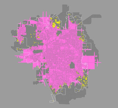
The workgroup's recommendations considered three factors: geographic coverage, unit reliability, and effective response force. The first is pretty obvious: how well does the plan do in putting resources within timely reach of the locations in the City where critical incidents such as fires and medical emergencies are likely to occur? The second, unit reliability, acknowledges that at any given time a given fire company may not be available: the crew could already be out on another incident, or in training, for instance. Finally, effective response force refers to the ability to assemble enough people and equipment to do the job. You cannot fight a structure fire with three firefighters, and two paramedics are not going to be able to deal with trauma patients at a traffic crash for very long before they need a lot more personnel to do the job properly.
Maximizing coverage, unit reliability, and effective response force is a matter of finding the right mix of both spreading out and concentrating resources. Finding that mix involved the application of demography, geography, and mathematics, informed by historical data about the fire and EMS workload, census data, and projections for Lincoln's future growth contained in the City's Comprehensive Plan. Focusing on geographic coverage, the pink area on the map below is the area that LF&R can travel to on the street network today within four minutes from Lincoln's current 14 fire stations. The dark gray area is the 25-year growth area of Lincoln, and there is a faint white border overlay that depicts the current city limits.
 |
| Click image for larger view |
 |
| Click image for larger view |


9 comments:
How about some maps that show the proposed areas of 4-minute response time? I think the concept is a good one, and I can't imagine anyone would have many objections to it other than (perhaps) people living next to the proposed new stations. Sirens and horns in the distance is one thing; right next door is another. I don't see much of a solution for that one, though.
Steve,
It will be in part 3, when I get a chance to write it. Monday or Tuesday, probably.
Sorry, I should have known the maps were coming. :)
What is the major cause of the dense number of calls in North Lincoln outside the 4 min time? Population density? Commecial Centers? It seems very focused.
Greg,
It is a high-growth area, with lots of senior citizen housing, large apartment complexes, and commercial development along and either side of N. 27th Street.
Director,
I don't know how you can accurately measure a four minute response time. For instance "O" Street at three o'clock in the morning and seven in the morning is going to be vastly different. Before spending million$ on relocating fire stations I hope things like managing traffic signals and improving traffic flows are investigated. Maybe ONE WAY streets or eliminating Left turn lanes at certain intersections? After all of these have been explored then relocation might be considered.
Gun Nut
Gun nut,
Travel time is calculated for such projections by simply using the speed limit on the street network. There is pretty good research that shows this to be a fairly accurate assessment of the actual travel time for fire apparatus in an emergency response condition.
We have a network of traffic signal preemption devices activated from fire apparatus. You'd love to have one of those transmitters, but alas....
How about some maps that show the proposed areas of 4-minute response time? I think the concept is a good one, and I can't imagine anyone would have many
seo optimization services
Jack,
You need to continue to Part 3!
Post a Comment